
Atsimo-Atsinanana topographic map
Interactive map
Click on the map to display elevation.
About this map
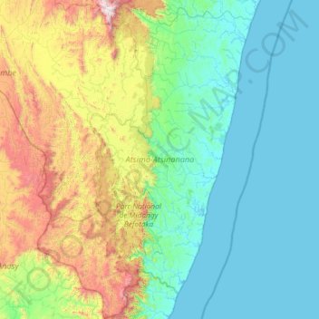
Name: Atsimo-Atsinanana topographic map, elevation, terrain.
Location: Atsimo-Atsinanana, Province de Fianarantsoa, Madagaskar (-24.29928 46.38503 -22.14818 47.96736)
Average elevation: 413 m
Minimum elevation: -1 m
Maximum elevation: 2,598 m
Other topographic maps
Click on a map to view its topography, its elevation and its terrain.
Farafangana
Madagaskar > Atsimo-Atsinanana > Farafangana
Farafangana, Atsimo-Atsinanana, Province de Fianarantsoa, Madagaskar
Average elevation: 4 m