
Thank you for supporting this site ❤️
Make a donation
Make a donation
São Bernardo do Campo topographic map
Click on the map to display elevation.
Thank you for supporting this site ❤️
Make a donation
Make a donation
São Bernardo do Campo
São Bernardo do Campo is located in the top of the Serra do Mar, on the Atlantic plateau. It occupies an area of 407.1 square kilometre. The altitude varies from a low of 60 meters above sea level at the foot of the mountain range where Rio Passareúva with the Rio Pilões rivers meet, to 986.5 meters at the peak of the Bonilha, in the Montanhão neighborhood.
Thank you for supporting this site ❤️
Make a donation
Make a donation
About this map
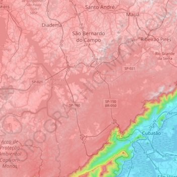
Name: São Bernardo do Campo topographic map, elevation, terrain.
Average elevation: 665 m
Minimum elevation: -3 m
Maximum elevation: 954 m
Thank you for supporting this site ❤️
Make a donation
Make a donation