
Sibbesse topographic map
Interactive map
Click on the map to display elevation.
About this map
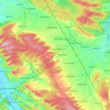
Name: Sibbesse topographic map, elevation, terrain.
Average elevation: 208 m
Minimum elevation: 85 m
Maximum elevation: 391 m
Other topographic maps
Click on a map to view its topography, its elevation and its terrain.
Sarstedt
Deutschland > Niedersachsen > Landkreis Hildesheim > Sarstedt > Sarstedt
Sarstedt liegt etwa 13 km nordwestlich von Hildesheim und 21 km südöstlich von Hannover. Sarstedt war zwischen 1885 und 1946 die einzige und ist seitdem die nördlichste Stadt im Landkreis Hildesheim. Westlich des Ortes verläuft die Innerste, welche vom Bruchgraben im Süden gespeist wird und 2 km weiter im…
Average elevation: 72 m