
Thank you for supporting this site ❤️
Make a donation
Make a donation
Fort Sill topographic map
Click on the map to display elevation.
Thank you for supporting this site ❤️
Make a donation
Make a donation
About this map
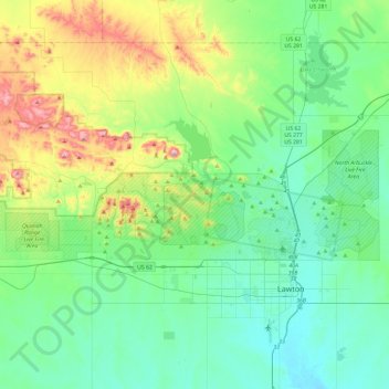
Name: Fort Sill topographic map, elevation, terrain.
Location: Fort Sill, Comanche County, Oklahoma, United States (34.63753 -98.75591 34.76803 -98.28239)
Average elevation: 417 m
Minimum elevation: 314 m
Maximum elevation: 749 m
Thank you for supporting this site ❤️
Make a donation
Make a donation
Other topographic maps
Click on a map to view its topography, its elevation and its terrain.
Medicine Bluffs
United States > Oklahoma > Comanche County > Lawton > White Wolf Bridge
Average elevation: 363 m
Thank you for supporting this site ❤️
Make a donation
Make a donation
Thank you for supporting this site ❤️
Make a donation
Make a donation