
Thank you for supporting this site ❤️
Make a donation
Make a donation
Guilers topographic map
Click on the map to display elevation.
Thank you for supporting this site ❤️
Make a donation
Make a donation
About this map
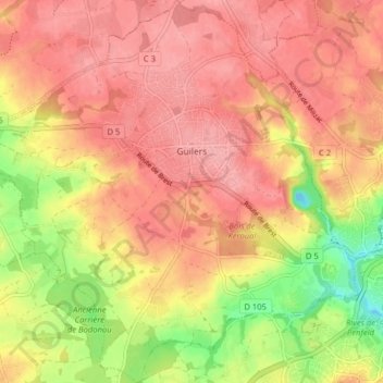
Name: Guilers topographic map, elevation, terrain.
Average elevation: 64 m
Minimum elevation: -5 m
Maximum elevation: 97 m
Thank you for supporting this site ❤️
Make a donation
Make a donation
Other topographic maps
Click on a map to view its topography, its elevation and its terrain.
Thank you for supporting this site ❤️
Make a donation
Make a donation
Thank you for supporting this site ❤️
Make a donation
Make a donation
Résidence de Porzh al Leur
France > Bretagne > Finistère > Châteauneuf-du-Faou
Average elevation: 101 m
Thank you for supporting this site ❤️
Make a donation
Make a donation
Ménez-Hom
France > Bretagne > Finistère > Dinéault
Le Ménez Hom prononcé localement et (en breton : Menez C'homm ) est une montagne située en Bretagne, dans le département du Finistère, en pays de Cornouaille, entre l'Aulne et le terroir de Porzay, sur le territoire des communes de Plomodiern, Saint-Nic, Trégarvan et Dinéault où elle culmine à 329…
Average elevation: 200 m
Thank you for supporting this site ❤️
Make a donation
Make a donation
Thank you for supporting this site ❤️
Make a donation
Make a donation