
Thank you for supporting this site ❤️
Make a donation
Make a donation
Andaman Islands topographic map
Click on the map to display elevation.
Thank you for supporting this site ❤️
Make a donation
Make a donation
About this map
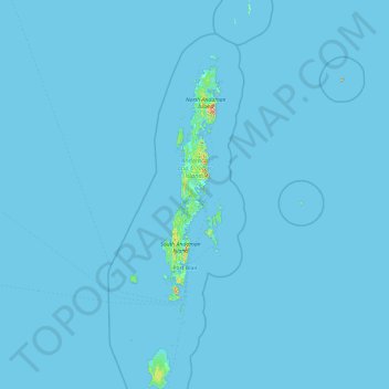
Name: Andaman Islands topographic map, elevation, terrain.
Location: Andaman Islands, Andaman and Nicobar Islands, India (10.51113 92.20421 14.19306 93.38267)
Average elevation: 2 m
Minimum elevation: -1 m
Maximum elevation: 662 m
Thank you for supporting this site ❤️
Make a donation
Make a donation
Other topographic maps
Click on a map to view its topography, its elevation and its terrain.
Thank you for supporting this site ❤️
Make a donation
Make a donation
Austinabad
India > Andaman and Nicobar Islands > Port Blair Tehsil > Port Blair
Average elevation: 23 m
Thank you for supporting this site ❤️
Make a donation
Make a donation
Car Nicobar Island
India > Andaman and Nicobar Islands > Car Nicobar > Malacca
Average elevation: 11 m
Thank you for supporting this site ❤️
Make a donation
Make a donation
Krishna nagar village
India > Andaman and Nicobar Islands > Krishna nagar village
Average elevation: 55 m
Thank you for supporting this site ❤️
Make a donation
Make a donation
Thank you for supporting this site ❤️
Make a donation
Make a donation
Car Nicobar Island
India > Andaman and Nicobar Islands > Car Nicobar > Tee Top
Average elevation: 11 m
Thank you for supporting this site ❤️
Make a donation
Make a donation