
Thank you for supporting this site ❤️
Make a donation
Make a donation
Newbury Township topographic map
Click on the map to display elevation.
Thank you for supporting this site ❤️
Make a donation
Make a donation
About this map
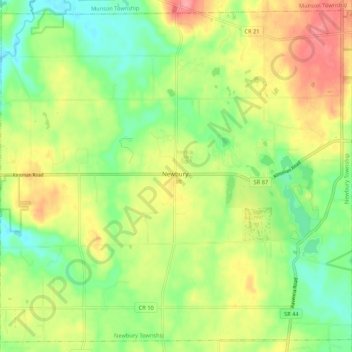
Name: Newbury Township topographic map, elevation, terrain.
Location: Newbury Township, Geauga County, Ohio, 44065, United States (41.42509 -81.29744 41.50058 -81.19051)
Average elevation: 367 m
Minimum elevation: 326 m
Maximum elevation: 420 m
Thank you for supporting this site ❤️
Make a donation
Make a donation
Other topographic maps
Click on a map to view its topography, its elevation and its terrain.