
Make a donation
Buffalo Plateau topographic map
Click on the map to display elevation.
Make a donation
Buffalo Plateau
The summit of the highest peak of the plateau, known as The Horn, has an elevation of 1,723 metres (5,653 ft) AHD.
Make a donation
About this map
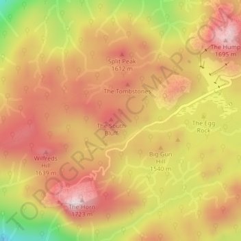
Name: Buffalo Plateau topographic map, elevation, terrain.
Average elevation: 1,502 m
Minimum elevation: 1,182 m
Maximum elevation: 1,700 m
Make a donation
Other topographic maps
Click on a map to view its topography, its elevation and its terrain.
City of Melbourne
Melbourne's topography is characterized by a diverse landscape that transitions from flat coastal plains to rolling hills and mountainous regions. The city is situated at the northern end of Port Phillip Bay, where the terrain is predominantly flat, facilitating urban development. As one moves eastward, the…
Average elevation: 18 m
Melbourne
Melbourne is also prone to isolated convective showers forming when a cold pool crosses the state, especially if there is considerable daytime heating. These showers are often heavy and can include hail, squalls, and significant drops in temperature, but they often pass through very quickly with a rapid…
Average elevation: 185 m
Make a donation
Make a donation
Make a donation
Grampians National Park
Mount William is known within the gliding community for the "Grampians Wave", a weather phenomenon that sometimes enables glider pilots to reach extreme altitudes of the order of 28,000 ft (8,500 m). This predominantly occurs during the months of May, June, September and October when strong westerly winds flow…
Average elevation: 262 m
Make a donation
Make a donation
Make a donation
Make a donation
Port Phillip
Port Phillip's mostly flat topography and moderate waves make perfect conditions for recreational swimming, kitesurfing, windsurfing, sailing, boating, snorkeling, scuba diving, stand up paddle boarding (SUP) and other sports.
Average elevation: 18 m
Make a donation
Make a donation
Make a donation
Make a donation
Mount Macedon
Due to its relatively high elevation of approximately 620 metres (2,030 ft) AHD, the area experiences much cooler temperatures on average relative to nearby Melbourne. The area also receives high rainfall relative to the surrounding plains and much of the Melbourne area. This combination of geographic factors…
Average elevation: 673 m
Make a donation
Mount Buller
Due to its far south-western location in the alpine region, Mount Buller is more susceptible to cold airmasses which allow it to record some of the lowest maximum temperatures and daytime readings in the country, despite being considerably lower in elevation than other mountain sites to the north-east. On 5…
Average elevation: 824 m
Omeo
There are bus routes from Bright and Bairnsdale. The Bairnsdale bus runs weekdays, once both directions, and the Bright bus (Alps Link) timetable is less frequent in Summer and runs additional services during the ski season. Alps Link is the highest altitude public bus in Australia. The town sits at the…
Average elevation: 861 m
Make a donation
Dandenong Ranges National Park - Ferntree Gully
Australia > Victoria > Montrose
The topography consists of a series of ridges dissected by deeply cut streams. Sheltered gullies in the south of the range are home to temperate rain forest, fern gullies and Mountain Ash forest Eucalyptus regnans, whereas the drier ridges and exposed northern slopes are covered by dry sclerophyll forest of…
Average elevation: 345 m
Yarra Ranges National Park
Australia > Victoria > Lake Mountain Alpine Resort
Average elevation: 465 m
Make a donation
Make a donation
Make a donation
Make a donation
Lancefield
Lancefield's elevation and climate made it a popular summer resort in the 1880s. In recent years, many local wineries have been established in the area.
Average elevation: 530 m
Make a donation
Make a donation
Make a donation
Make a donation
Make a donation
Frankston
Olivers Hill is the most prominent elevation in Frankston which rises to 55 metres above sea level (180 feet) at its highest point in the suburb. Its origins date to approximately 415 to 360 million years ago. Its base is Mount Eliza Granite dating from the Devonian period, which was covered in lava tuffs in…
Average elevation: 40 m
Make a donation
Make a donation
Make a donation