Geolocate
👉 Easily get elevation data in JSON, GeoTIFF and KML formats using Elevation API
Thank you for supporting this site ❤️
Make a donation

Acconia topographic map

Click on the map to display elevation.

👉 Easily get elevation data in JSON, GeoTIFF and KML formats using Elevation API
Thank you for supporting this site ❤️
Make a donation

About this map

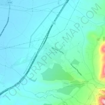
Name: Acconia topographic map, elevation, terrain.

Location: Acconia, Curinga, Catanzaro, Calabria, 88022, Italy (38.81600 16.24572 38.85600 16.28572)

Average elevation: 49 m

Minimum elevation: 3 m

Maximum elevation: 301 m

Other topographic maps

Click on a map to view its topography, its elevation and its terrain.

Badolato

Italy > Calabria > Catanzaro

Average elevation: 327 m

Platania

Italy > Calabria > Catanzaro

Average elevation: 865 m

Argusto

Italy > Calabria > Catanzaro

Average elevation: 470 m

Santa Caterina dello Ionio

Italy > Calabria > Catanzaro

Average elevation: 293 m