
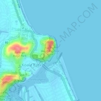
Burleigh Head National Park topographic map
Interactive map
Click on the map to display elevation.
About this map
Name: Burleigh Head National Park topographic map, elevation, terrain.
Average elevation: 7 m
Minimum elevation: -4 m
Maximum elevation: 74 m
Other topographic maps
Click on a map to view its topography, its elevation and its terrain.
Gold Coast
Australia > Queensland > Gold Coast
Gold Coast, Queensland, 4217, Australia
Average elevation: 42 m
Beechmont
Australia > Queensland > Gold Coast > Beechmont
Beechmont, Gold Coast, Queensland, Australia
Average elevation: 413 m
Tallebudgera Creek
Australia > Queensland > Gold Coast
Tallebudgera Creek, Gold Coast, Queensland, 4219, Australia
Average elevation: 11 m
Pimpama
Australia > Queensland > Gold Coast > Pimpama
Pimpama, Gold Coast, Queensland, 4209, Australia
Average elevation: 19 m
Binna Burra
Australia > Queensland > Gold Coast
Binna Burra, Gold Coast, Queensland, Australia
Average elevation: 535 m
Reedy Creek
Australia > Queensland > Gold Coast
Reedy Creek, Gold Coast, Queensland, 4227, Australia
Average elevation: 16 m
Lower Beechmont
Australia > Queensland > Gold Coast
Lower Beechmont, Gold Coast, Queensland, Australia
Average elevation: 297 m
Nerang State Forest
Australia > Queensland > Gold Coast
Nerang State Forest, Baileys, Nerang, Gold Coast, Queensland, 4211, Australia
Average elevation: 65 m
South Stradbroke Island
Australia > Queensland > Gold Coast
South Stradbroke Island, Gold Coast, Queensland, Australia
Average elevation: 3 m
Clagiraba
Australia > Queensland > Gold Coast
Clagiraba, Gold Coast, Queensland, Australia
Average elevation: 122 m
Hinze Dam
Australia > Queensland > Gold Coast
Hinze Dam, Gold Coast, Queensland, Australia
Average elevation: 89 m
Southern Moreton Bay Islands
Australia > Queensland > Gold Coast
Southern Moreton Bay Islands, Gold Coast, Queensland, Australia
Average elevation: 2 m
Maudsland
Australia > Queensland > Gold Coast
Maudsland, Gold Coast, Queensland, Australia
Average elevation: 43 m
Guanaba
Australia > Queensland > Gold Coast
Guanaba, Gold Coast, Queensland, Australia
Average elevation: 51 m
Tamborine
Australia > Queensland > Gold Coast
Tamborine, Gold Coast, Queensland, 4270, Australia
Average elevation: 50 m
The Spit
Australia > Queensland > Gold Coast
The Spit, Gold Coast, Queensland, 4215, Australia
Average elevation: 2 m
South Stradbroke Island
Australia > Queensland > Gold Coast
South Stradbroke Island, Gold Coast, Queensland, 4216, Australia
Average elevation: 45 m
Willow Vale
Australia > Queensland > Gold Coast
Willow Vale, Gold Coast, Queensland, Australia
Average elevation: 83 m
Springbrook
Australia > Queensland > Gold Coast > Springbrook
Springbrook, Gold Coast, Queensland, 4213, Australia
Average elevation: 554 m
Guanaba
Australia > Queensland > Gold Coast
Guanaba, Gold Coast, Queensland, Australia
Average elevation: 154 m
Brisbane (Mount Staplyton) Weather Radar
Australia > Queensland > Gold Coast
Brisbane (Mount Staplyton) Weather Radar, Johnstone Road, Stapylton, Gold Coast, Queensland, 4207, Australia
Average elevation: 20 m
Gilston
Australia > Queensland > Gold Coast
Gilston, Gold Coast, Queensland, Australia
Average elevation: 68 m
Kingsholme
Australia > Queensland > Gold Coast
Kingsholme, Gold Coast, Queensland, Australia
Average elevation: 127 m
Gold Coast Seaway
Australia > Queensland > Gold Coast
Gold Coast Seaway, Federation Trail, Main Beach, Gold Coast, Queensland, 4217, Australia
Average elevation: 1 m
Tugun Hill
Australia > Queensland > Gold Coast
Tugun Hill, Gold Coast, Queensland, 4224, Australia
Average elevation: 13 m
Pine Ridge Conservation Park
Australia > Queensland > Gold Coast
Pine Ridge Conservation Park, Hollywell, Gold Coast, Queensland, Australia
Average elevation: 4 m
Coomera River
Australia > Queensland > Gold Coast
Coomera River, Gold Coast, Queensland, Australia
Average elevation: 555 m
Canowindra
Australia > Queensland > Gold Coast > Canowindra
Canowindra, Pimpama, Gold Coast, Queensland, 4208, Australia
Average elevation: 20 m
Kurrawa
Australia > Queensland > Gold Coast
Kurrawa, Gold Coast, Queensland, 4217, Australia
Average elevation: 2 m
Advancetown
Australia > Queensland > Gold Coast
Advancetown, Gold Coast, Queensland, 4211, Australia
Average elevation: 77 m
Reedy Creek
Australia > Queensland > Gold Coast
Reedy Creek, Gold Coast, Queensland, 4227, Australia
Average elevation: 40 m
Gilberton
Australia > Queensland > Gold Coast
Gilberton, Gold Coast, Queensland, 4208, Australia
Average elevation: 4 m
Mount Razorback
Australia > Queensland > Gold Coast
Mount Razorback, Gold Coast, Queensland, Australia
Average elevation: 643 m
Kerry
Australia > Queensland > Gold Coast
Kerry, Gold Coast, Queensland, Australia
Average elevation: 143 m
Nerang River
Australia > Queensland > Gold Coast
Nerang River, Gold Coast, Queensland, Australia
Average elevation: 492 m
Coomera River
Australia > Queensland > Gold Coast
Coomera River, Gold Coast, Queensland, Australia
Average elevation: 563 m
Reedy Creek
Australia > Queensland > Gold Coast
Reedy Creek, Gold Coast, Queensland, 4227, Australia
Average elevation: 25 m
Araucaria Forest
Australia > Queensland > Gold Coast
Araucaria Forest, Benowa, Gold Coast, Queensland, Australia
Average elevation: 6 m
Green Mountains
Australia > Queensland > Gold Coast
Green Mountains, Gold Coast, Queensland, Australia
Average elevation: 774 m
Mount Wanungara
Australia > Queensland > Gold Coast
Mount Wanungara, Gold Coast, Queensland, Australia
Average elevation: 962 m
Lake Hugh Muntz
Australia > Queensland > Gold Coast
Lake Hugh Muntz, Long Island Court, Mermaid Waters, Gold Coast, Queensland, 4218, Australia
Average elevation: 4 m
Boronia Park
Australia > Queensland > Gold Coast
Boronia Park, Broadbeach, Gold Coast, Queensland, Australia
Average elevation: 3 m
Mount Bithongabel
Australia > Queensland > Gold Coast
Mount Bithongabel, Gold Coast, Queensland, Australia
Average elevation: 928 m
Toolona Creek
Australia > Queensland > Gold Coast
Toolona Creek, Gold Coast, Queensland, Australia
Average elevation: 994 m
Black Stump Park
Australia > Queensland > Gold Coast
Black Stump Park, Molendinar, Gold Coast, Queensland, Australia
Average elevation: 14 m
Gaven
Australia > Queensland > Gold Coast
Gaven, Gold Coast, Queensland, 4214, Australia
Average elevation: 52 m
Loders Creek
Australia > Queensland > Gold Coast
Loders Creek, Gold Coast, Queensland, 4214, Australia
Average elevation: 18 m
Tamborine National Park
Australia > Queensland > Gold Coast
Tamborine National Park, Dapsang Drive, North Tamborine, Gold Coast, Queensland, 4272, Australia
Average elevation: 176 m
Toolona
Australia > Queensland > Gold Coast
Toolona, Gold Coast, Queensland, Australia
Average elevation: 956 m