
Thank you for supporting this site ❤️
Make a donation
Make a donation
Dilsberg topographic map
Click on the map to display elevation.
Thank you for supporting this site ❤️
Make a donation
Make a donation
About this map
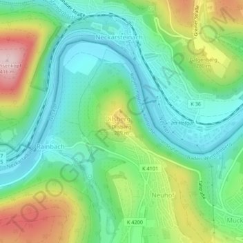
Name: Dilsberg topographic map, elevation, terrain.
Average elevation: 207 m
Minimum elevation: 109 m
Maximum elevation: 413 m
Thank you for supporting this site ❤️
Make a donation
Make a donation
Other topographic maps
Click on a map to view its topography, its elevation and its terrain.
Mückenloch
Deutschland > Baden-Württemberg > Rhein-Neckar-Kreis > Neckargemünd
In Mückenloch gibt es drei Kirchen: Die katholische Kirche in der Ortsmitte geht auf die Zeit der Ortsgründung zurück. Jedoch stürzten bei Bauarbeiten für ein neues Kirchenschiff der unter Denkmalschutz stehende Kirchturm und die umfassende Kirchenmauer teilweise ein. Daraufhin wurde 1974 die Kirche neu…
Average elevation: 231 m
Waldhilsbach
Deutschland > Baden-Württemberg > Rhein-Neckar-Kreis > Neckargemünd
Average elevation: 238 m