
Thank you for supporting this site ❤️
Make a donation
Make a donation
Port Moody topographic map
Click on the map to display elevation.
Thank you for supporting this site ❤️
Make a donation
Make a donation
About this map
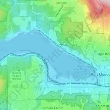
Name: Port Moody topographic map, elevation, terrain.
Location: Port Moody, Metro Vancouver, British Columbia, Canada (49.27992 -122.91097 49.30190 -122.83500)
Average elevation: 103 m
Minimum elevation: -1 m
Maximum elevation: 529 m
Thank you for supporting this site ❤️
Make a donation
Make a donation