
Arkansas topographic map
Interactive map
Click on the map to display elevation.
About this map
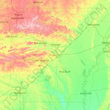
Name: Arkansas topographic map, elevation, terrain.
Location: Arkansas, Estados Unidos (33.00411 -94.61786 36.49960 -89.64225)
Average elevation: 156 m
Minimum elevation: 13 m
Maximum elevation: 812 m
Other topographic maps
Click on a map to view its topography, its elevation and its terrain.
Horseshoe Bend
Estados Unidos > Arkansas > Horseshoe Bend
Horseshoe Bend, Izard County, Arkansas, 72512, Estados Unidos
Average elevation: 211 m
Barling
Estados Unidos > Arkansas > Barling > Barling
Barling, Sebastian County, Arkansas, 72923, Estados Unidos
Average elevation: 135 m