
Make a donation
Hawaiian Beaches topographic map
Click on the map to display elevation.
Make a donation
About this map
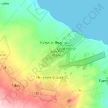
Name: Hawaiian Beaches topographic map, elevation, terrain.
Location: Hawaiian Beaches, Hawaiʻi County, Hawaii, United States (19.49814 -154.97347 19.56469 -154.84770)
Average elevation: 90 m
Minimum elevation: 0 m
Maximum elevation: 289 m
Make a donation
Other topographic maps
Click on a map to view its topography, its elevation and its terrain.
Volcano
United States > Hawaii > Hawaiʻi County
Its altitude ranges from below 2,800 feet (850 m) in the southeast to over 6,200 feet (1,900 m) at its uninhabited northern end. Due to this, Volcano features a subtropical highland climate (Köppen Cfb), with relatively uniform temperatures and abundant rainfall throughout the year, although rainfall is…
Average elevation: 1,144 m
Make a donation
Make a donation
Kohala
United States > Hawaii > Hawaiʻi County
In Kohala, the numerous dikes near the summit inhibit groundwater from seeping downslope to the northeast, where it naturally wants to go. Rather, the Kohala dike complex guides it northwest or southeast, down the axis of the rift zones, just like the surface water. On the other hand, the three smaller valleys…
Average elevation: 1,489 m
Kukuihaele CDP
United States > Hawaii > Hawaiʻi County
Kukuihaele is located on the north side of the island of Hawaii at 20°7′10″N 155°34′16″W / 20.11944°N 155.57111°W / 20.11944; -155.57111 (20.119536, -155.571160). It sits at an elevation of 730 feet (220 m) atop cliffs overlooking Waipio Bay. Hawaii Route 240 passes through the southern…
Average elevation: 173 m
Make a donation
Make a donation
Make a donation
Kukuihaele
United States > Hawaii > Hawaiʻi County
Kukuihaele is located on the north side of the island of Hawaii at 20°7′10″N 155°34′16″W / 20.11944°N 155.57111°W / 20.11944; -155.57111 (20.119536, -155.571160). It sits at an elevation of 730 feet (220 m) atop cliffs overlooking Waipio Bay. Hawaii Route 240 passes through the southern…
Average elevation: 188 m
Make a donation
Make a donation