
Make a donation
Khobar Governorate topographic map
Click on the map to display elevation.
Make a donation
About this map
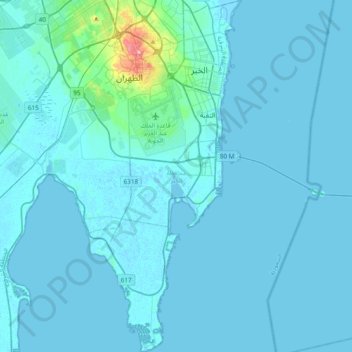
Name: Khobar Governorate topographic map, elevation, terrain.
Location: Khobar Governorate, Eastern Province, Saudi Arabia (26.02949 50.07442 26.37135 50.32444)
Average elevation: 6 m
Minimum elevation: -5 m
Maximum elevation: 133 m
Make a donation
Other topographic maps
Click on a map to view its topography, its elevation and its terrain.
Make a donation
Make a donation
Ar Rub` al Khali
Saudi Arabia > Eastern Province > Al Ahsa Governorate
The desert is 1,000 kilometres (620 miles) long, and 500 kilometres (310 miles) wide. Its surface elevation varies from 800 metres (2,600 ft) in the southwest to around sea level in the northeast. Most of the terrain is ergs, with sand dunes up to 250 metres (820 ft) high, interspersed with gravel and gypsum…
Average elevation: 183 m
Make a donation
Make a donation
Make a donation
Make a donation
Make a donation
Make a donation
Make a donation
Make a donation
Make a donation
Make a donation
Al Qarah Mountain
Saudi Arabia > Eastern Province > Al Ahsa Governorate > الدالوة
Average elevation: 142 m
Make a donation
Make a donation
Ar Rub` al Khali
Saudi Arabia > Eastern Province > Al Ahsa Governorate
The desert is 1,000 kilometres (620 miles) long, and 500 kilometres (310 miles) wide. Its surface elevation varies from 800 metres (2,600 ft) in the southwest to around sea level in the northeast.[4] The terrain is covered with sand dunes with heights up to 250 metres (820 ft), interspersed with gravel and…
Average elevation: 183 m
Make a donation
Make a donation
Make a donation