
Huanta topographic map
Interactive map
Click on the map to display elevation.
Huanta
Huanta liegt 25 km Luftlinie und 47,7 Straßenkilometer nördlich der Regionshauptstadt Huamanga (Ayacucho) auf einer Höhe von 2627 m über dem Meeresspiegel (msnm) und hat ein gemäßigt warmes Klima. Mit 31.757 Einwohnern (Zensus 2017) ist Huanta nach Huamanga die zweitgrößte Stadt der Region Ayacucho. 10 Jahre zuvor lag die Einwohnerzahl bei 26.026.
About this map
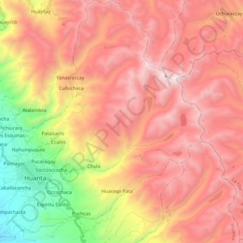
Name: Huanta topographic map, elevation, terrain.
Location: Huanta, Ayacucho, Peru (-12.98451 -74.29942 -12.81800 -74.12872)
Average elevation: 3,811 m
Minimum elevation: 2,361 m
Maximum elevation: 4,883 m