
Alt St. Johann topographic map
Interactive map
Click on the map to display elevation.
About this map
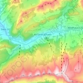
Name: Alt St. Johann topographic map, elevation, terrain.
Average elevation: 1,429 m
Minimum elevation: 833 m
Maximum elevation: 2,306 m
Other topographic maps
Click on a map to view its topography, its elevation and its terrain.
Wildhaus
Suisse > Saint-Gall > Wahlkreis Toggenburg > Wildhaus-Alt St. Johann
Wildhaus, Wildhaus-Alt St. Johann, Wahlkreis Toggenburg, Saint-Gall, 9658, Suisse
Average elevation: 1,244 m
Schönenboden
Suisse > Saint-Gall > Wahlkreis Toggenburg > Wildhaus-Alt St. Johann
Schönenboden, Wildhaus, Wildhaus-Alt St. Johann, Wahlkreis Toggenburg, Saint-Gall, 9658, Suisse
Average elevation: 1,273 m