
Thank you for supporting this site ❤️
Make a donation
Make a donation
Hart an der Alz topographic map
Click on the map to display elevation.
Thank you for supporting this site ❤️
Make a donation
Make a donation
About this map
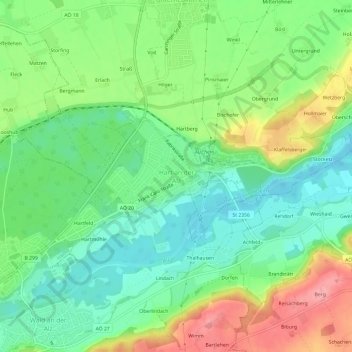
Name: Hart an der Alz topographic map, elevation, terrain.
Average elevation: 460 m
Minimum elevation: 418 m
Maximum elevation: 532 m
Thank you for supporting this site ❤️
Make a donation
Make a donation
Other topographic maps
Click on a map to view its topography, its elevation and its terrain.
84518
Deutschland > Bayern > Landkreis Altötting > Garching an der Alz > Wald an der Alz
Average elevation: 458 m