
Make a donation
East Cleveland topographic map
Click on the map to display elevation.
Make a donation
East Cleveland
Most of the city is located in a relatively flat and relatively lower area contiguous with the city of Cleveland. A small portion of the city lies atop a steep hill, and is contiguous with the neighboring city of Cleveland Heights; it also lies in a relatively flat area at a higher elevation. Superior Road, Forest Hills Boulevard, Lee Road, Noble and North Taylor roads are the major through-streets ascending the hill. The McGregor Home and the Forest Hill Historic District are located on "the hill." The city is notable for its high amount of abandoned buildings.
Make a donation
About this map
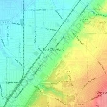
Name: East Cleveland topographic map, elevation, terrain.
Location: East Cleveland, Cuyahoga County, Ohio, 44112, United States (41.51555 -81.59863 41.54806 -81.55545)
Average elevation: 224 m
Minimum elevation: 188 m
Maximum elevation: 287 m
Make a donation
Other topographic maps
Click on a map to view its topography, its elevation and its terrain.
Cuyahoga Valley National Park
United States > Ohio > Cuyahoga County > Independence
Average elevation: 209 m
Cleveland
United States > Ohio > Cuyahoga County > Cleveland
The land rises quickly from the lake shore elevation of 569 feet. Public Square, less than one mile (1.6 km) inland, sits at an elevation of 650 feet (198 m), and Hopkins Airport, 5 miles (8 km) inland from the lake, is at an elevation of 791 feet (241 m).
Average elevation: 219 m
Make a donation