
Make a donation
Monroe County topographic map
Click on the map to display elevation.
Make a donation
Monroe County
The western part of the county on the Mississippi River is part of the American Bottom floodplain, while the eastern portion of the county is relatively flat and was originally prairie. The transition zone between has high bluffs of limestone and dolomite and has distinctive Karst topography with numerous sinkholes, caves, and springs. Mississippi River bluffs along Monroe County's western border make the county part of the “Illinois Ozarks.” The county's roughly 500 limestone sinkholes, most filled with dense woods, add to Monroe County's unusual visual appeal.
Make a donation
About this map
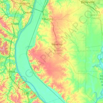
Name: Monroe County topographic map, elevation, terrain.
Location: Monroe County, Illinois, United States (38.08791 -90.37305 38.52078 -89.89680)
Average elevation: 157 m
Minimum elevation: 108 m
Maximum elevation: 269 m
Make a donation
Other topographic maps
Click on a map to view its topography, its elevation and its terrain.
Sturbridge Village
United States > Illinois > Winnebago County > Sturbridge Village
Average elevation: 230 m
Make a donation