
Thank you for supporting this site ❤️
Make a donation
Make a donation
Rhea County topographic map
Click on the map to display elevation.
Thank you for supporting this site ❤️
Make a donation
Make a donation
About this map
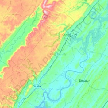
Name: Rhea County topographic map, elevation, terrain.
Location: Rhea County, East Tennessee, Tennessee, United States (35.40929 -85.14651 35.82523 -84.71147)
Average elevation: 378 m
Minimum elevation: 202 m
Maximum elevation: 915 m
Thank you for supporting this site ❤️
Make a donation
Make a donation
Other topographic maps
Click on a map to view its topography, its elevation and its terrain.
Thank you for supporting this site ❤️
Make a donation
Make a donation
Thank you for supporting this site ❤️
Make a donation
Make a donation
Shepherd
United States > Tennessee > Hamilton County > Chattanooga > Shepherd
Average elevation: 212 m
Thank you for supporting this site ❤️
Make a donation
Make a donation