
Annweiler am Trifels topographic map
Interactive map
Click on the map to display elevation.
About this map
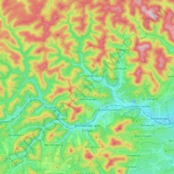
Name: Annweiler am Trifels topographic map, elevation, terrain.
Average elevation: 339 m
Minimum elevation: 149 m
Maximum elevation: 654 m
Other topographic maps
Click on a map to view its topography, its elevation and its terrain.
Schweigen-Rechtenbach
Allemagne > Rhénanie-Palatinat > Landkreis Südliche Weinstraße
Schweigen-Rechtenbach, Bad Bergzabern, Landkreis Südliche Weinstraße, Rhénanie-Palatinat, Allemagne
Average elevation: 252 m