
Thank you for supporting this site ❤️
Make a donation
Make a donation
Mazet-Saint-Voy topographic map
Click on the map to display elevation.
Thank you for supporting this site ❤️
Make a donation
Make a donation
About this map
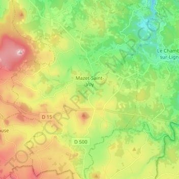
Name: Mazet-Saint-Voy topographic map, elevation, terrain.
Average elevation: 1,079 m
Minimum elevation: 874 m
Maximum elevation: 1,380 m
Thank you for supporting this site ❤️
Make a donation
Make a donation
Other topographic maps
Click on a map to view its topography, its elevation and its terrain.
Peyredeyre
France > Auvergne-Rhône-Alpes > Haute-Loire > Chaspinhac > Peyredeyre
Average elevation: 739 m
Thank you for supporting this site ❤️
Make a donation
Make a donation
Château abbatial
France > Auvergne-Rhône-Alpes > Haute-Loire > Le Monastier-sur-Gazeille > Artaud
Average elevation: 938 m