
Thank you for supporting this site ❤️
Make a donation
Make a donation
Topsham topographic map
Click on the map to display elevation.
Thank you for supporting this site ❤️
Make a donation
Make a donation
About this map
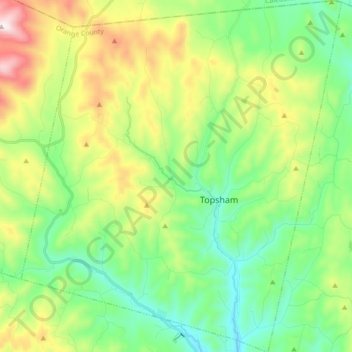
Name: Topsham topographic map, elevation, terrain.
Location: Topsham, Orange County, Vermont, United States (44.06601 -72.33137 44.19266 -72.17069)
Average elevation: 454 m
Minimum elevation: 216 m
Maximum elevation: 948 m
Thank you for supporting this site ❤️
Make a donation
Make a donation
Other topographic maps
Click on a map to view its topography, its elevation and its terrain.
Thank you for supporting this site ❤️
Make a donation
Make a donation
Thank you for supporting this site ❤️
Make a donation
Make a donation
Thank you for supporting this site ❤️
Make a donation
Make a donation