
Thank you for supporting this site ❤️
Make a donation
Make a donation
Inveresk topographic map
Click on the map to display elevation.
Thank you for supporting this site ❤️
Make a donation
Make a donation
About this map
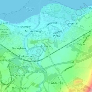
Name: Inveresk topographic map, elevation, terrain.
Location: Inveresk, East Lothian, Scotland, EH21 7TE, United Kingdom (55.91555 -3.06434 55.95555 -3.02434)
Average elevation: 22 m
Minimum elevation: 0 m
Maximum elevation: 124 m
Thank you for supporting this site ❤️
Make a donation
Make a donation
Other topographic maps
Click on a map to view its topography, its elevation and its terrain.