
L'Étang Boyé topographic map
Interactive map
Click on the map to display elevation.
About this map
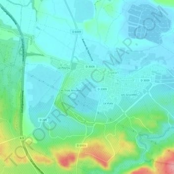
Name: L'Étang Boyé topographic map, elevation, terrain.
Average elevation: 25 m
Minimum elevation: -2 m
Maximum elevation: 112 m
Other topographic maps
Click on a map to view its topography, its elevation and its terrain.
Port Mahon
France > Occitanie > Aude > Sigean
Port Mahon, L'Aragnou, Sigean, Narbonne, Aude, Occitanie, France métropolitaine, 11130, France
Average elevation: 5 m
Les Grazelles
France > Occitanie > Aude > Sigean
Les Grazelles, Sigean, Narbonne, Aude, Occitanie, France métropolitaine, 11130, France
Average elevation: 28 m