
Thank you for supporting this site ❤️
Make a donation
Make a donation
Le Châtelet-sur-Meuse topographic map
Click on the map to display elevation.
Thank you for supporting this site ❤️
Make a donation
Make a donation
About this map
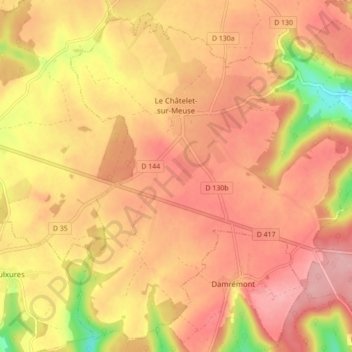
Name: Le Châtelet-sur-Meuse topographic map, elevation, terrain.
Average elevation: 394 m
Minimum elevation: 301 m
Maximum elevation: 442 m
Thank you for supporting this site ❤️
Make a donation
Make a donation
Other topographic maps
Click on a map to view its topography, its elevation and its terrain.
La Trace
France > Grand Est > Haute-Marne > Roches-Bettaincourt > Bettaincourt-sur-Rognon
Average elevation: 271 m
Thank you for supporting this site ❤️
Make a donation
Make a donation