
Thank you for supporting this site ❤️
Make a donation
Make a donation
Poggio Mirteto topographic map
Click on the map to display elevation.
Thank you for supporting this site ❤️
Make a donation
Make a donation
About this map
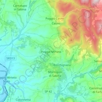
Name: Poggio Mirteto topographic map, elevation, terrain.
Location: Poggio Mirteto, Rieti, Lazio, 02047, Italy (42.23653 12.61238 42.29552 12.73451)
Average elevation: 278 m
Minimum elevation: 28 m
Maximum elevation: 1,039 m
Thank you for supporting this site ❤️
Make a donation
Make a donation
Other topographic maps
Click on a map to view its topography, its elevation and its terrain.