Geolocate
👉 Easily get elevation data in JSON, GeoTIFF and KML formats using Elevation API
Thank you for supporting this site ❤️
Make a donation

Racine topographic map

Click on the map to display elevation.

👉 Easily get elevation data in JSON, GeoTIFF and KML formats using Elevation API
Thank you for supporting this site ❤️
Make a donation

About this map

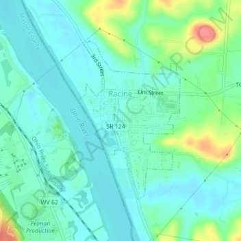
Name: Racine topographic map, elevation, terrain.

Location: Racine, Meigs County, Ohio, United States (38.95929 -81.92042 38.97712 -81.90571)

Average elevation: 185 m

Minimum elevation: 167 m

Maximum elevation: 241 m

Other topographic maps

Click on a map to view its topography, its elevation and its terrain.

Dyesville

United States > Ohio > Meigs County

Average elevation: 218 m

Plants

United States > Ohio > Meigs County

Average elevation: 198 m