
Make a donation
Lago Vista topographic map
Click on the map to display elevation.
Make a donation
Lago Vista
According to the United States Census Bureau, the city has a total area of 15.52 sq mi (40.2 km2) of which 14.6 sq mi (38 km2) is land and 0.6 sq mi (1.6 km2) (3.95%) is water. The peninsular city sits adjacent to, and partially within, the Balcones Canyonlands. Lago Vista has rugged terrain with elevations ranging from 774 ft (236 m) above sea level at the lake shore to 1220 ft (372 m) above sea level near Rusty Allen Airport. The area is characterized by steep limestone hills and canyons, some of the highest in Travis County.
Make a donation
About this map
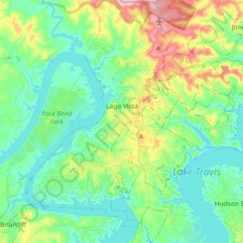
Name: Lago Vista topographic map, elevation, terrain.
Location: Lago Vista, Travis County, Texas, United States (30.39919 -98.03744 30.50717 -97.95484)
Average elevation: 251 m
Minimum elevation: 196 m
Maximum elevation: 388 m
Make a donation