
Thank you for supporting this site ❤️
Make a donation
Make a donation
Kasese topographic map
Click on the map to display elevation.
Thank you for supporting this site ❤️
Make a donation
Make a donation
About this map
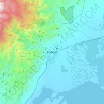
Name: Kasese topographic map, elevation, terrain.
Location: Kasese, Western Region, Uganda (0.01238 29.92570 0.33238 30.24570)
Average elevation: 1,348 m
Minimum elevation: 912 m
Maximum elevation: 4,205 m
Thank you for supporting this site ❤️
Make a donation
Make a donation