
Thank you for supporting this site ❤️
Make a donation
Make a donation
Hateg topographic map
Click on the map to display elevation.
Thank you for supporting this site ❤️
Make a donation
Make a donation
About this map
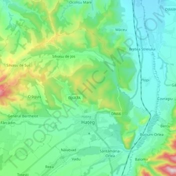
Name: Hateg topographic map, elevation, terrain.
Location: Hateg, Hunedoara, Romania (45.58576 22.82712 45.67775 22.99178)
Average elevation: 365 m
Minimum elevation: 250 m
Maximum elevation: 768 m
Thank you for supporting this site ❤️
Make a donation
Make a donation
Other topographic maps
Click on a map to view its topography, its elevation and its terrain.