
Make a donation
Isla de Mona topographic map
Click on the map to display elevation.
Make a donation
Isla de Mona
Mona is a mainly flat plateau surrounded by sea cliffs. It is composed of dolomite and limestone with many caves found throughout. With an arid climate and untouched by human development, many endemic species inhabit the island, such as the Mona ground iguana (Cyclura cornuta stejnegeri). Its topography, ecology, and modern history are similar to that of Navassa Island, a small limestone island located in the Jamaica Channel, between Jamaica and Haiti.
Make a donation
About this map
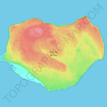
Name: Isla de Mona topographic map, elevation, terrain.
Location: Isla de Mona, Mayagüez, Puerto Rico, United States (18.05297 -67.94586 18.12185 -67.84365)
Average elevation: 26 m
Minimum elevation: -1 m
Maximum elevation: 88 m
Make a donation
Other topographic maps
Click on a map to view its topography, its elevation and its terrain.
Desecheo Island
United States > Puerto Rico > Mayagüez
Desecheo, which has no known bodies of surface water, reaches a maximum elevation of 715 ft (218 m) and has an annual precipitation, on average, of 40.15 in (1020 mm). The lack of surface water limits its flora to thorny shrubs, small trees, weeds and various cacti, including the endangered higo chumbo…
Average elevation: 9 m
Mayagüez
United States > Puerto Rico > Mayagüez
Mayagüez has a tropical monsoon climate (Köppen climate classification Am). The city has the most extreme weather of the island. The high frequency of severe storms in the summer can produce strong winds, floods, waterspouts, and sometimes hail and even tornadoes. The average annual temperature is 75 °F (24…
Average elevation: 93 m