
Thank you for supporting this site ❤️
Make a donation
Make a donation
Lac Margie topographic map
Click on the map to display elevation.
Thank you for supporting this site ❤️
Make a donation
Make a donation
About this map
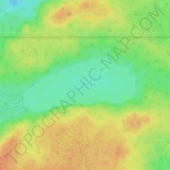
Name: Lac Margie topographic map, elevation, terrain.
Location: Lac Margie, Eeyou Istchee, Northern Quebec, Quebec, Canada (49.67456 -76.20281 49.68331 -76.17523)
Average elevation: 318 m
Minimum elevation: 295 m
Maximum elevation: 338 m
Thank you for supporting this site ❤️
Make a donation
Make a donation
Other topographic maps
Click on a map to view its topography, its elevation and its terrain.
Whapmagoostui (Category I Land)
Canada > Quebec > Eeyou Istchee > Whapmagoostui (Village)
Average elevation: 91 m
Thank you for supporting this site ❤️
Make a donation
Make a donation
Thank you for supporting this site ❤️
Make a donation
Make a donation