
Make a donation
Zapata Swamp topographic map
Click on the map to display elevation.
Make a donation
Zapata Swamp
The Zapata Swamp lies between 22°01’ and 22°40’ N latitude and between 80°33’ and 82°09’ W longitude. The swamp in total is over one million acres (4,000 km2). Topographically, the maximum height above sea level is only about 10 meters with the top depth in below-sea-level coastal zones as follows: 2 meters in the saltmarsh area and from 1–600 meters in the sea coastal zone. Between May and October, the warmest season of the year, average temperature is 30 °C (86 °F). Between November and April, the coldest season of the year, the temperature on average is 20 °C (68 °F).
Make a donation
About this map
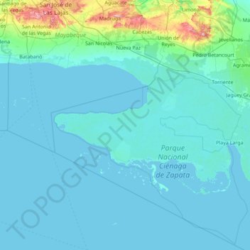
Name: Zapata Swamp topographic map, elevation, terrain.
Location: Zapata Swamp, Matanzas, Cuba (22.04939 -82.15773 22.69275 -80.79560)
Average elevation: 18 m
Minimum elevation: -2 m
Maximum elevation: 292 m
Make a donation
Other topographic maps
Click on a map to view its topography, its elevation and its terrain.