
Thank you for supporting this site ❤️
Make a donation
Make a donation
Espelkamp topographic map
Click on the map to display elevation.
Thank you for supporting this site ❤️
Make a donation
Make a donation
About this map
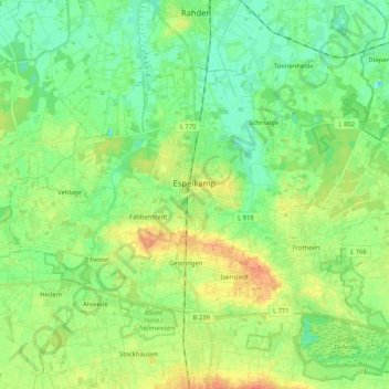
Name: Espelkamp topographic map, elevation, terrain.
Average elevation: 50 m
Minimum elevation: 36 m
Maximum elevation: 74 m
Thank you for supporting this site ❤️
Make a donation
Make a donation
Other topographic maps
Click on a map to view its topography, its elevation and its terrain.
Griepshop
Duitsland > Noordrijn-Westfalen > Kreis Minden-Lübbecke > Rothenuffeln
Average elevation: 98 m