
Make a donation
Town of Wallkill topographic map
Click on the map to display elevation.
Make a donation
About this map
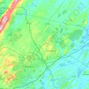
Name: Town of Wallkill topographic map, elevation, terrain.
Location: Town of Wallkill, Orange County, New York, United States (41.42249 -74.51105 41.56576 -74.27681)
Average elevation: 169 m
Minimum elevation: 103 m
Maximum elevation: 403 m
Make a donation
Other topographic maps
Click on a map to view its topography, its elevation and its terrain.
Highland Mills
United States > New York > Orange County > Village of Woodbury
Average elevation: 208 m
Make a donation
Newburgh
United States > New York > Orange County
Adjacent to Newburgh, the land rises at first sharply to a bluff, where many historic structures are located, offering sweeping views of the Hudson Highlands to the south; Mount Beacon to the east and the Newburgh—Beacon Bridge to the north; then more gradually to a relatively level western half. There are…
Average elevation: 148 m
Make a donation
Beaver Dam Lake
United States > New York > Orange County > Town of New Windsor
Average elevation: 118 m
Make a donation
Make a donation
Vails Gate Junction
United States > New York > Orange County > Town of New Windsor > Vails Gate
Average elevation: 92 m
Make a donation
Cornwall Landing
United States > New York > Orange County > Village of Cornwall-on-Hudson
Average elevation: 74 m
Make a donation
Nathaniel Wetlands Inventory - R5UBH - 0.09 acres
United States > New York > Orange County
Average elevation: 138 m