
Thank you for supporting this site ❤️
Make a donation
Make a donation
Clearcreek Township topographic map
Click on the map to display elevation.
Thank you for supporting this site ❤️
Make a donation
Make a donation
About this map
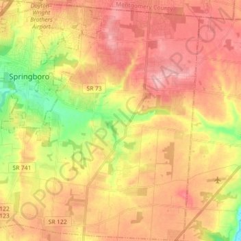
Name: Clearcreek Township topographic map, elevation, terrain.
Location: Clearcreek Township, Warren County, Ohio, United States (39.47816 -84.25982 39.58655 -84.13384)
Average elevation: 282 m
Minimum elevation: 211 m
Maximum elevation: 331 m
Thank you for supporting this site ❤️
Make a donation
Make a donation
Other topographic maps
Click on a map to view its topography, its elevation and its terrain.
Thank you for supporting this site ❤️
Make a donation
Make a donation
Corwin M. Nixon Pine Hill Lakes Park
United States > Ohio > Warren County > Mason
Average elevation: 250 m