
Thank you for supporting this site ❤️
Make a donation
Make a donation
Old Fort topographic map
Click on the map to display elevation.
Thank you for supporting this site ❤️
Make a donation
Make a donation
About this map
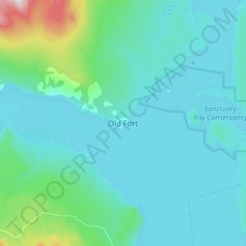
Name: Old Fort topographic map, elevation, terrain.
Average elevation: 784 m
Minimum elevation: 699 m
Maximum elevation: 1,349 m
Thank you for supporting this site ❤️
Make a donation
Make a donation
Other topographic maps
Click on a map to view its topography, its elevation and its terrain.
Houston Tommy Creek
Canada > British Columbia > Regional District of Bulkley-Nechako > Area G (Morice Valley/Babine Valley)
Average elevation: 1,242 m