
Tombeek topographic map
Interactive map
Click on the map to display elevation.
About this map
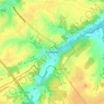
Name: Tombeek topographic map, elevation, terrain.
Location: Tombeek, Isque, Hal-Vilvorde, Brabant flamand, 3090, Belgique (50.73391 4.54741 50.77391 4.58741)
Average elevation: 78 m
Minimum elevation: 33 m
Maximum elevation: 135 m
Other topographic maps
Click on a map to view its topography, its elevation and its terrain.
Malaise
Belgique > Brabant flamand > Hal-Vilvorde > Isque > Malaise
Malaise, Isque, Hal-Vilvorde, Brabant flamand, Flandre, 1331, Belgique
Average elevation: 87 m