
Make a donation
Mazandaran Province topographic map
Click on the map to display elevation.
Make a donation
Mazandaran Province
Mazandaran province naturally comes under the influence of the geographical latitude, the Alborz mountain range, elevation from sea level, distance from the sea, and the southern barren areas of Turkmenistan, local and regional air currents, and versatile vegetation cover. These conditions result in the climatic division of the province into three types: (1) Moderate Caspian weather with hot, humid summers and mild, humid winters, (2) moderate mountainous weather with long, cold and freezing winters and mild and short summers, and (3) cold mountainous weather with long freezing winters and short cool summers. There is often snowfall during most of the seasons in the latter region, which continues till mid-summer.
Make a donation
About this map
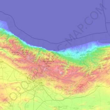
Name: Mazandaran Province topographic map, elevation, terrain.
Location: Mazandaran Province, Iran (35.76136 50.33429 37.13744 54.17297)
Average elevation: 863 m
Minimum elevation: -29 m
Maximum elevation: 5,470 m
Make a donation
Other topographic maps
Click on a map to view its topography, its elevation and its terrain.
Padig
Iran > Sistan and Baluchestan Province > Sarbaz County > دهستان سرکور
Average elevation: 1,305 m
Make a donation
Baba Jan, East Azerbaijan
Iran > East Azerbaijan Province > Ahar County > دهستان قشلاق
Average elevation: 1,752 m
Make a donation
Lorega
Iran > Chaharmahal and Bakhtiyari Province > Kuhrang County > دهستان میان کوه موگوئی
Average elevation: 3,364 m