
Thank you for supporting this site ❤️
Make a donation
Make a donation
Western Province topographic map
Click on the map to display elevation.
Thank you for supporting this site ❤️
Make a donation
Make a donation
About this map
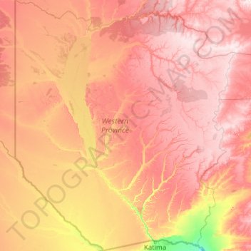
Name: Western Province topographic map, elevation, terrain.
Location: Western Province, Zambia (-17.63787 21.99935 -13.71273 25.58648)
Average elevation: 1,069 m
Minimum elevation: 927 m
Maximum elevation: 1,249 m
Thank you for supporting this site ❤️
Make a donation
Make a donation
Other topographic maps
Click on a map to view its topography, its elevation and its terrain.
Choma
Choma lies on the Lusaka–Livingstone Road, approximately 292 kilometres (181 mi) south-west of Lusaka, the national capital and largest city in Zambia. This is approximately 194 kilometres (121 mi), by road, northeast of Livingstone, the largest city in Zambia's Southern Province. The geographical…
Average elevation: 1,310 m