
West Midlands topographic map
Interactive map
Click on the map to display elevation.
About this map
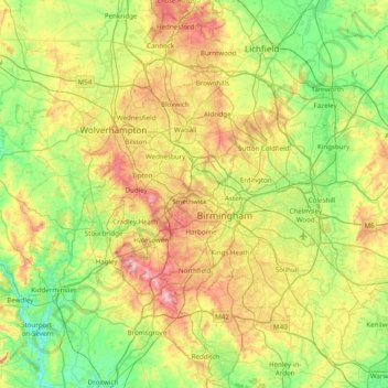
Name: West Midlands topographic map, elevation, terrain.
Average elevation: 113 m
Minimum elevation: 15 m
Maximum elevation: 307 m
Other topographic maps
Click on a map to view its topography, its elevation and its terrain.
West Malvern
Vereinigtes Königreich > England > Worcestershire
West Malvern, Worcestershire, England, Vereinigtes Königreich
Average elevation: 198 m
Bretforton
Vereinigtes Königreich > England > Worcestershire > Wychavon > Bretforton
Bretforton, Wychavon, Worcestershire, West Midlands, England, Vereinigtes Königreich
Average elevation: 42 m