
Rohr im Kremstal topographic map
Interactive map
Click on the map to display elevation.
About this map
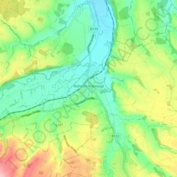
Name: Rohr im Kremstal topographic map, elevation, terrain.
Location: Rohr im Kremstal, Bezirk Steyr-Land, 4532, Österreich (48.04428 14.15001 48.08785 14.24049)
Average elevation: 367 m
Minimum elevation: 311 m
Maximum elevation: 465 m
Rohr im Kremstal liegt auf 346 m Höhe im Traunviertel in der Mitte des fruchtbaren Kremstales, dort wo der Sulzbach in die Krems mündet. Es ist die westlichste Gemeinde des Bezirkes Steyr-Land und grenzt an die Bezirke Kirchdorf und Linz-Land. Die Ausdehnung beträgt von Nord nach Süd 6,6 km, von West nach Ost 4,9 km. Die Gesamtfläche beträgt 13,6 km². 5,9 % der Fläche sind bewaldet, 83,1 % der Fläche sind landwirtschaftlich genutzt.
Other topographic maps
Click on a map to view its topography, its elevation and its terrain.
Rotstein
Österreich > Bezirk Steyr-Land > Großraming
Rotstein, Großraming, Bezirk Steyr-Land, 4463, Österreich
Average elevation: 618 m
Reichraming
Österreich > Bezirk Steyr-Land
Reichraming, Bezirk Steyr-Land, 4462, Österreich
Average elevation: 800 m
Maria Neustift
Österreich > Bezirk Steyr-Land
Maria Neustift, Bezirk Steyr-Land, 4443, Österreich
Average elevation: 634 m
Obsweyer
Österreich > Bezirk Steyr-Land
Obsweyer, Weyer, Bezirk Steyr-Land, 3335, Österreich
Average elevation: 561 m
Bad Hall
Österreich > Bezirk Steyr-Land
Bad Hall, Bezirk Steyr-Land, 4540, Österreich
Average elevation: 389 m
Gaflenz
Österreich > Bezirk Steyr-Land
Gaflenz, Bezirk Steyr-Land, 3334, Österreich
Average elevation: 674 m
Saaß
Österreich > Bezirk Steyr-Land
Saaß, Aschach an der Steyr, Bezirk Steyr-Land, 4421, Österreich
Average elevation: 389 m