
Thank you for supporting this site ❤️
Make a donation
Make a donation
Avrig topographic map
Click on the map to display elevation.
Thank you for supporting this site ❤️
Make a donation
Make a donation
About this map
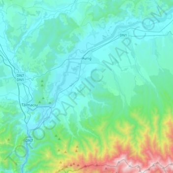
Name: Avrig topographic map, elevation, terrain.
Location: Avrig, Sibiu, Romania (45.57252 24.27808 45.80506 24.50584)
Average elevation: 655 m
Minimum elevation: 350 m
Maximum elevation: 2,394 m
Thank you for supporting this site ❤️
Make a donation
Make a donation
Other topographic maps
Click on a map to view its topography, its elevation and its terrain.
Bâlea Lake
Romania > Sibiu > Cârțișoara
Bâlea Lake (Romanian: Lacul Bâlea or Bâlea Lac, pronounced [ˈbɨle̯a]; Hungarian: Bilea-tó) is a glacier lake situated at 2,034 m of altitude in the Făgăraș Mountains, in central Romania, in Cârțișoara, Sibiu County. There are two chalets opened all the year round, a meteorological station and a…
Average elevation: 2,080 m
Thank you for supporting this site ❤️
Make a donation
Make a donation