
Make a donation
Akçaabat topographic map
Click on the map to display elevation.
Make a donation
Akçaabat
Akçaabat is a municipality and district of Trabzon Province, Turkey. Its area is 375 km2, and its population is 129,290 (2022). It lies on the Black Sea coast, to the west of the city of Trabzon. Its elevation is ten metres (33 ft). Akçaabat is a coastal town known for its local soccer team Akçaabat Sebatspor, its kofta dish Akçaabat köfte and the Akçaabat Horonu dance. Akçaabat has hosted an international folklore festival since 1990, and it was a venue for Archery and Athletics competitions of the First Black Sea Games held in 2007.
Make a donation
About this map
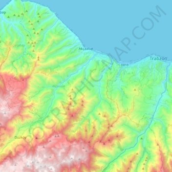
Name: Akçaabat topographic map, elevation, terrain.
Location: Akçaabat, Trabzon, Black Sea Region, Turkey (40.81564 39.39351 41.10174 39.64365)
Average elevation: 563 m
Minimum elevation: 0 m
Maximum elevation: 1,982 m
Make a donation
Other topographic maps
Click on a map to view its topography, its elevation and its terrain.
Make a donation