
Thank you for supporting this site ❤️
Make a donation
Make a donation
Amos topographic map
Click on the map to display elevation.
Thank you for supporting this site ❤️
Make a donation
Make a donation
About this map
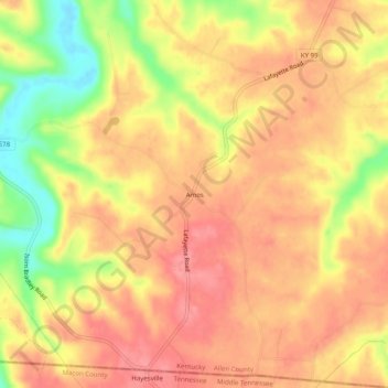
Name: Amos topographic map, elevation, terrain.
Location: Amos, Allen County, Kentucky, 42153, United States (36.63255 -86.10832 36.67255 -86.06832)
Average elevation: 244 m
Minimum elevation: 186 m
Maximum elevation: 273 m
Thank you for supporting this site ❤️
Make a donation
Make a donation
Other topographic maps
Click on a map to view its topography, its elevation and its terrain.