
Thank you for supporting this site ❤️
Make a donation
Make a donation
General Todorov topographic map
Click on the map to display elevation.
Thank you for supporting this site ❤️
Make a donation
Make a donation
About this map
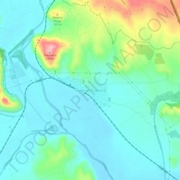
Name: General Todorov topographic map, elevation, terrain.
Location: General Todorov, Petrich, Blagoevgrad, 2873, Bulgaria (41.43478 23.26645 41.47478 23.30645)
Average elevation: 116 m
Minimum elevation: 79 m
Maximum elevation: 236 m
Thank you for supporting this site ❤️
Make a donation
Make a donation
Other topographic maps
Click on a map to view its topography, its elevation and its terrain.