
Make a donation
Araucanía Region topographic map
Click on the map to display elevation.
Make a donation
About this map
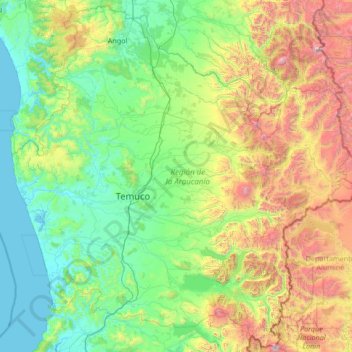
Name: Araucanía Region topographic map, elevation, terrain.
Location: Araucanía Region, Chile (-39.63722 -73.51907 -37.58180 -70.82723)
Average elevation: 654 m
Minimum elevation: -2 m
Maximum elevation: 3,695 m
Make a donation
Other topographic maps
Click on a map to view its topography, its elevation and its terrain.
Zona Austral
Chile > Region of Magallanes and Chilean Antarctica > Provincia de Última Esperanza > Puerto Natales
In the far south (Chile Austral), which extends from Valdivia through the Chacao Channel to Cape Horn, the Andes and the South Pacific meet. This district of the country is mountainous, heavily forested and inhospitable. The deeply indented coastline is filled with islands which preserve the general outline of…
Average elevation: 768 m
Puerto Williams
Chile > Magallanes and Chilean Antarctica Region > Provincia de la Antártica Chilena > Cape Horn
The climate of Puerto Williams is a tundra climate (ET) bordering closely on a subpolar oceanic climate (Cfc) according to the Köppen climate classification. The summers are short and cool while the winters are long, wet, but moderate. Rainfall is around 512.3 mm (20 in) a year and temperatures are steady…
Average elevation: 151 m
Villa Alegre
Chile > Santiago Metropolitan Region > Provincia de Melipilla > Melipilla
Average elevation: 144 m
Lo Solar
Chile > Santiago Metropolitan Region > Provincia de Chacabuco > Estación Colina
Average elevation: 498 m
Make a donation
Mineral El Salvador
Chile > Atacama Region > Provincia de Chañaral > Diego de Almagro
Average elevation: 2,772 m
Comunidad Juan Neculqueo
Chile > Araucanía Region > Provincia de Cautín > Temuco
Average elevation: 110 m
Villa Cerro Castillo
Chile > Aysén Region > Provincia de General Carrera > Río Ibáñez
Average elevation: 379 m
Make a donation
Norte Grande
Chile > Antofagasta Region > Provincia de Antofagasta > Sierra Gorda
The desert region is an elevated arid plateau descending gradually from the Andes towards the coast, where it breaks down abruptly from elevations of 800 to 1500 ft. From the sea this plateau escarpment has the appearance of a range of flat topped hills closely following the coast line. This topography…
Average elevation: 2,112 m
Chair
Chile > Region of Magallanes and Chilean Antarctica > Provincia de la Antártica Chilena > Cape Horn
Average elevation: 18 m
Make a donation
Viña del Mar
Chile > Valparaiso Region > Provincia de Valparaíso > Viña del Mar
Average elevation: 152 m
Cape Horn
Chile > Region of Magallanes and Chilean Antarctica > Provincia de la Antártica Chilena > Cape Horn
Average elevation: 49 m
Make a donation
Volcán Villarrica
Chile > Araucanía Region > Provincia de Cautín > Villarrica
Average elevation: 2,316 m