
Thank you for supporting this site ❤️
Make a donation
Make a donation
Rotinet topographic map
Click on the map to display elevation.
Thank you for supporting this site ❤️
Make a donation
Make a donation
About this map
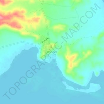
Name: Rotinet topographic map, elevation, terrain.
Location: Rotinet, Repelón, Atlántico, Colombia (10.50802 -75.09018 10.54802 -75.05018)
Average elevation: 22 m
Minimum elevation: 3 m
Maximum elevation: 95 m
Thank you for supporting this site ❤️
Make a donation
Make a donation
Other topographic maps
Click on a map to view its topography, its elevation and its terrain.